AI-powered construction monitoring platform
We built a web platform that turns drone flights into AI progress reports for a GCC developer’s construction sites — within minutes of upload, instead of weeks after a site visit.
- Industry
- Construction, Real estate, Infrastructure
- Region
- GCC
- Services
- Product discovery, UX/UI design, Software architecture, AI/ML engineering, DevOps
- Timeline
- 2025–2026 (Phase 1 complete, Phase 2 planned)
- Project kicked off
- 2025
- Active construction sites
- 5+
- Platform replacing fragmented tools
- 1
Intro
A GCC-based development company runs several construction projects at once — public parks, road systems, commercial roundabouts and mixed-use developments — each in a different phase. Their tracking process could not keep up.
Progress was measured through periodic site inspections and spreadsheet reports. Some sites had drone footage, but it was never connected to schedules, design data or any consistent analysis, so updates to government bodies and investors rested on estimates rather than verifiable data.
S-PRO assessed the client’s needs, reviewed the available technologies and brought us in as the delivery partner. We designed and built the platform; S-PRO managed the engagement.
Goals and challenges
The client needed one platform that turns raw drone imagery into construction intelligence: progress tracked automatically, delays surfaced early, and every stakeholder working from the same evidence.
- 01
Replace manual inspections with automated monitoring
Every site needed a physical visit, photos and a hand-assembled report. The process was slow, varied with whoever did the inspection and did not scale across projects — by the time a report reached a decision-maker, its data was usually one to two weeks old. The goal: make drone flights the primary data source and produce progress assessments within minutes of upload.
- 02
Connect drone data to project intelligence
Reporting was disconnected from design plans, timelines and milestones, so a project manager could not tell how far along a specific component was or whether the project was on schedule. The platform had to overlay drone imagery on design plans, compare flights over time and answer the question every stakeholder asks: are we on schedule?
- 03
Evidence-based reporting for stakeholders
The client reports to government entities, investors and contractors, all of whom need progress updates backed by data. Those reports used to be assembled by hand from scattered sources and depended on individual judgement. The client needed structured reports that stakeholders can verify.
Solution
We delivered the Construction Monitoring Platform: a web application that combines drone data processing, AI progress analysis, interactive 2D/3D visualization and project management in one system.
S-PRO coordinated with Etijah, who defined the tech stack and brought core expertise in geospatial data, computer vision and construction technology. We took the engagement from discovery to a production-ready product.
Construction AI: automated progress detection
The AI engine analyzes drone orthomosaics against design plans and estimates completion for the whole project and for individual components. Every estimate comes with a confidence score and evidence from the imagery: what was expected versus what was observed.
When a new flight is uploaded and processed, the platform generates a detailed report within minutes, showing which components are progressing, which are behind and where the site diverges from the plan. The next phase adds warnings for data-quality issues — shadows, obstructions, plan-versus-site mismatches — so teams know how far to trust each estimate.
2D/3D visualization and measurement
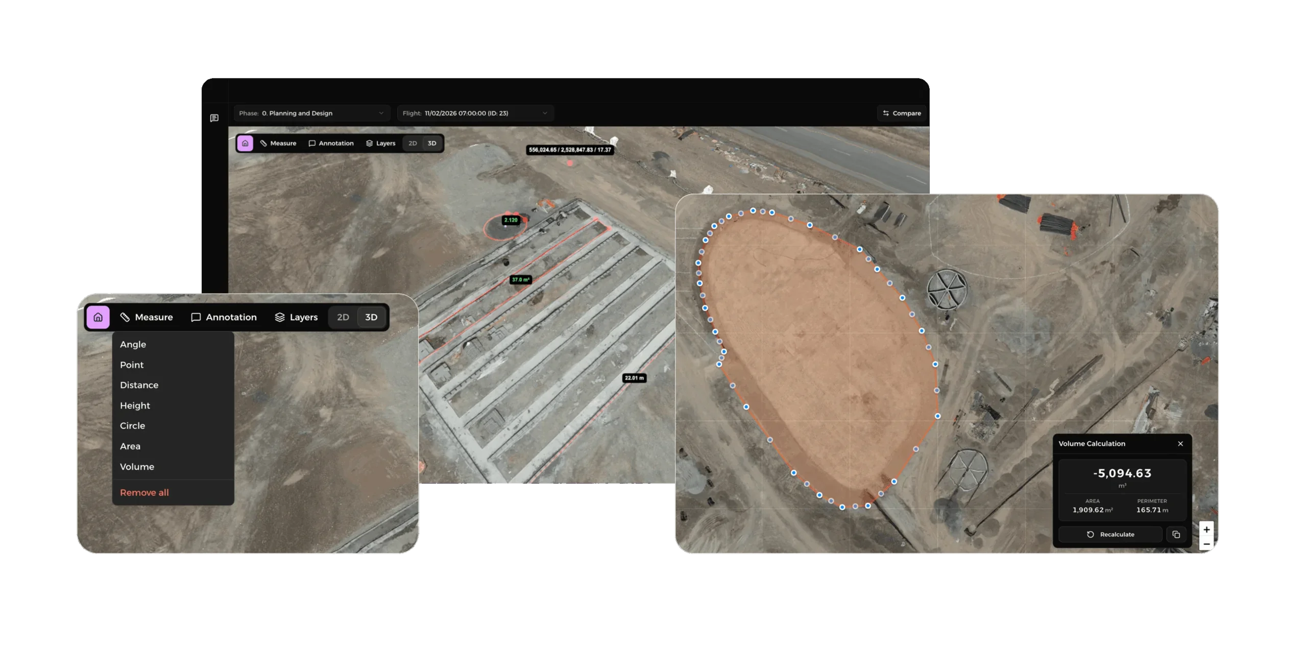
Drone data is processed into interactive orthomosaics and 3D point clouds that open in the browser. Built-in tools measure distance, area and earthwork volume without external CAD or GIS software.
A comparison mode shows two flights side by side with synchronized navigation, and CAD overlays place design drawings on top of drone imagery with adjustable opacity, so teams can check construction against the plans.
Flight management and data processing
The platform covers the full drone data lifecycle: upload, automated processing with OpenDroneMap, and generation of orthophotos, point clouds, surface models and reports. Teams upload raw flight imagery and get processed outputs back inside the platform — no manual file handling or third-party processing tools.
Project management and collaboration
Work is organized into projects, phases and milestones, with budget tracking, role-based access control and status flags for on-track, ahead and delayed projects. Annotations pin observations to the 3D model or 2D map, flag issues and assign follow-ups.
An executive dashboard gives leadership a portfolio-wide view: status distribution, progress trends, budget utilization and a map of every active site.
Core components
- AI progress analysis with Vision Language Models and per-component confidence scores
- Interactive 2D/3D viewer on Potree, Three.js and Leaflet with measurement and annotation tools
- Automated drone data pipeline with OpenDroneMap for orthomosaics and point clouds
- Role-based project management with phases, milestones and budget tracking
- CAD overlays for design-versus-reality comparison
Technology and infrastructure
- Browser-based, no desktop software required
- OpenDroneMap for photogrammetric processing
- Vision Language Models for progress estimation
- Potree and Three.js for 3D point cloud rendering
- Leaflet with OpenStreetMap for 2D mapping
- Role-based access control with project-level permissions
- RTK/IMU/GPS telemetry support
Team
S-PRO acted as strategic technology partner: client needs assessment, delivery partner selection and engagement oversight. Our delivery team covered product, design, architecture, AI and infrastructure.
- Product Manager / Business Analyst
- UX/UI Designer
- Software Architect
- AI/ML Engineer (VLM integration and prompt engineering)
- DevOps / Infrastructure
The client’s operations, project management and executive stakeholders worked as product partners throughout — contributing domain knowledge, validating requirements and reviewing builds. Feedback ran mostly through offline review cycles rather than frequent calls, which kept reviews close to the client’s real workflows.
Results
The platform reached its final demo milestone in March 2026. Project managers who used to drive to sites and assemble reports by hand now get AI-generated progress reports within minutes of a drone flight, each with observations from the imagery and confidence scores.
With 2D/3D visualization, anyone on the project can explore a site remotely, take measurements, compare progress over time and flag issues on the model. Conversations with contractors, investors and government stakeholders now rest on visual, verifiable data instead of written estimates.
Construction AI does not reduce a project to a single percentage. It breaks the project into its real components — for a park development, the roundabout, the road network and the park facilities are analyzed separately, down to sub-components — so it is clear which piece is behind.
Permissions were designed in from the start: contractors see only their projects, while project managers and executives see the full portfolio — essential when every project involves stakeholders with different access needs.
- Platform modules delivered
- 7
- Phase 2 features on the roadmap
- 33
- Drone images for a primary site
- 1,000+
What’s next
Phase 2 has 33 features mapped out: multi-turn AI conversations about site data, voice input for field queries, 4D timeline views that animate progress over time, anomaly detection that flags delays early, and time-limited links for external stakeholders.
S-PRO is leading the Phase 2 proposal and talks about extending the platform to other government entities, aiming to repeat the same model — understand the client’s real problem, pick the right delivery partner, manage the engagement closely — in other construction markets across the GCC.
Project details
- Client
- A leading GCC-based development company (anonymous)
- Industry
- Construction, Real estate, Infrastructure
- Region
- GCC
- Platform
- Web application (SaaS)
- Services
- Product discovery, UX/UI design, Software architecture, AI/ML engineering, DevOps
- Partners
- Technologies
- Vision Language Models
- OpenDroneMap
- Potree
- Three.js
- Leaflet
- OpenStreetMap
- RTK/IMU/GPS telemetry
- Team
- 5 roles — product, design, architecture, AI/ML, DevOps
- Timeline
- 2025–2026 (Phase 1 complete, Phase 2 planned)
- Links
Discover more
Faster APIs, automation and AI recommendations for WKO Inhouse
Gov · App development · Recommendation System · OpenAI · Data Science

LLM-based credit scoring using transaction data
Scoring systems · Data Science · Fintech

AI content processing and recommendations for the Kyiv Independent
Data Science · OpenAI · Recommendation System